


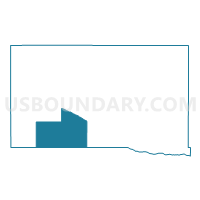
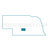
Ringgold Precinct, Dawson County, Nebraska
About
Outline

Summary
| Unique Area Identifier | 612703 |
| Name | Ringgold Precinct |
| County | Dawson County |
| State | Nebraska |
| Area (square miles) | 82.07 |
| Land Area (square miles) | 80.83 |
| Water Area (square miles) | 1.25 |
| % of Land Area | 98.48 |
| % of Water Area | 1.52 |
| Latitude of the Internal Point | 40.75226890 |
| Longtitude of the Internal Point | -99.98095540 |
Maps

Graphs
Select a template below for downloading or customizing gragh for Ringgold Precinct, Dawson County, Nebraska


Neighbors
Neighoring Voting District (by Name) Neighboring Voting District on the Map
- Coyote Precinct, Dawson County, NE
- Cozad East Precinct, Dawson County, NE
- Cozad West Precinct, Dawson County, NE
- Eustis Precinct, Frontier County, NE
- Fairview Precinct, Dawson County, NE
- Farnam Precinct, Dawson County, NE
- Platte Precinct, Dawson County, NE
- Precinct 2, Gosper County, NE
Top 10 Neighboring County Subdivision (by Population) Neighboring County Subdivision on the Map
- Platte precinct, Dawson County, NE (613)
- Coyote precinct, Dawson County, NE (550)
- Fairview precinct, Frontier County, NE (496)
- Gillan precinct, Dawson County, NE (475)
- Ringgold precinct, Dawson County, NE (337)
- Fairview precinct, Dawson County, NE (250)
- Farnam precinct, Dawson County, NE (216)
- Cozad precinct, Dawson County, NE (152)
- Brace precinct, Gosper County, NE (112)
- Plum Creek precinct, Frontier County, NE (42)
Top 10 Neighboring Unified School District (by Population) Neighboring Unified School District on the Map
- Lexington Public Schools, NE (12,327)
- Cozad City Schools, NE (5,227)
- Elwood Public Schools, NE (1,828)
- Eustis-Farnam Public Schools, NE (1,066)
Top 10 Neighboring State Legislative District Upper Chamber (by Population) Neighboring State Legislative District Upper Chamber on the Map
- State Senate District 36, NE (37,224)
- State Senate District 44, NE (33,011)
- State Senate District 38, NE (32,734)
Top 10 Neighboring 111th Congressional District (by Population) Neighboring 111th Congressional District on the Map
Top 10 Neighboring Census Tract (by Population) Neighboring Census Tract on the Map
- Census Tract 9611, Frontier County, NE (2,756)
- Census Tract 9676, Gosper County, NE (2,044)
- Census Tract 9686, Dawson County, NE (1,573)